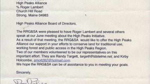
High Peaks Alliance holds forum in Phillips to discuss local national wildlife refuge.

Valerie Tucker, Special to the Sun Journal

Franklin |

Wednesday, February 20, 2013 at 10:15 pm

PHILLIPS — The High Peaks Alliance launched its first of several discussion forums Wednesday evening to introduce the concept of a national wildlife refuge based in northwestern Franklin County.

The nonprofit organization’s mission has been the creation and retention of traditional-use access for hunters, hikers, guides, snowmobilers and ATV riders.

The evening gathering, sponsored by the Sandy River Business Association, shared some of the group’s successes in supporting landowner cooperation, access easements and conflict resolutions. When a landowner subdivides and sells a single-piece property with a single trail, future recreational users must get permission to access each property to continue to use that trail. Property owners have the right to refuse access, said forum organizer Chris Beach, but the Alliance has worked hard to bring those recreational users and landowners to the table.

Continue reading

Advice on a High Peaks Wildlife Rufuge from Friends of Rachel Carson-President, Bill Durkin.


There are many reports and studies that have been published detailing the economic benefits of conserving lands. The direct positive impacts on the local, regional and state economy are plentiful: outdoor tourism, hotel occupancy levels, general stores, retail shopping venues, food establishments, the list is endless. There are also many indirect benefits that we may not think about in our day-to-day lives of what a national wildlife refuge in the region may accomplish. Take a hike along rugged mountain path, x-country ski over open fields, bird watch in a dense forest, canoe on a meandering stream, go hunt and fish in your favorite spot, or take an exhilarating ride on your snowmobile. All of these activities enhance our quality of life and Maine’s economy. Establishing a  National Wildlife Refuge in the Maine High Peaks region will protect wildlife habitat and it is a vehicle to acquire important lands for public use. Monies used to acquire parcels come from the Land, Water and Conservation Funds (LWCF), which uses revenues generated from offshore energy leases – not taxpayer dollars. LWCF has helped conserve some of Maine’s most special places, including Acadia National Park, Moosehorn NWR, Rachel Carson NWR, Coastal Islands NWR and the Appalachian Trail; these lands are permanently  protected. The process of creating a National Wildlife Refuge can be long and tedious but the final result will make you feel good; conserving habitat is well worth the price.


Bill Durkin

President

The Friends of Rachel Carson National Wildlife Refuge

Maine


Atlantic Salmon Restoration in the Sandy River Watershed of the High Peaks Region.

Follow the link below to see department of Marine Resources Paul Christman and fellow workers plant Atlantic Salmon eggs in the Sandy River.

The Orbeton Stream working forest conservation project will help protect the headwaters of the Sandy River, already identified as prime habitat for this endangered species.

Atlantic Salmon Video

And check out the full article here:

http://www.pressherald.com/sports/pressherald_com_2012-02-05.html?searchterm=salmon

Protected: Public access to 17,000 acres of working forests in the High Peaks Region

Orbeton Stream

The U.S Forest Service recently announced that Maine would receive $8.7 million in federal grants to protect 17,000 acres of working forest from development and promote recreation in Franklin County’s High Peaks Region. Included are 5,800 acres surrounding the Orbeton Stream in Madrid Township and 11,800 acres on and around Crocker Mountain in Carrabassett Valley

“This is exciting news for all the recreational trail groups in the High Peaks Region,” says Lloyd Griscom of the High Peaks Alliance. “We are grateful to the many individuals, organizations, businesses, schools and trail clubs who supported the 2012 Forest Legacy application.  It has taken more than four years of hard work. And while there is still a need to raise additional money from the private sector for the two parcels (stay tuned) there is light at the end of the tunnel. ”

The 5,800 acre Orbeton Stream parcel is best known for the fledgling Fly Rod Crosby Trail that passes through the heart of it on its way from Strong to Oquossoc. The land, which is owned by Linkletter Timberlands, a family run business located in Athens, would remain privately owned but would have an easement stipulating that it would always be managed for wood products and be open to public recreation. It is currently home to ATV, snowmobile and hiking trails, is a very popular hunting and fishing destination and a source of income for local Maine Guides.

The 11,800 acre Crocker Mountain parcel is best known for the 10 miles of the Appalachian Trail which makes it way through it.  The parcel, which is owned by Plum Creek, would be purchased by the State of Maine ; timber harvesting will continue on the property with guarantees for public access to  other types of recreation including hunting, mountain biking and cross country skiing.

The Fly Rod Crosby Trail takes its name from local heroine Cornelia “Fly Rod” Crosby, Maine’s first Registered Guide and the first person to market this area as a destination for early recreation.. The 45- mile -long trail will eventually connect the communities of Strong, Phillips, Madrid, Sandy River Plantation, Rangeley and Oquossoc through back-country hiking and other forms of recreation.  A  section of the Fly Rod Crosby Trail was built, on the Orbeton Stream parcel by volunteers in 2010-11 with  generous permission from  Linkletter Timberlands.

Volunteers working on the Fly Rod Crosby Trail

The Orbeton Stream parcel is also home to the Moose Loop ATV and Black Fly Loop Snowmobile Systems. The Black Fly Loop, which is run cooperatively by seven local snowmobile clubs, has been in place in the High Peaks Region for more than the  10 years and provides access to over 300 miles of trails in the region. In 2010, the High Peaks Alliance assisted local organizers to start the Moose Loop Trail, which stretches almost 140 miles and is run cooperatively by seven local ATV clubs.

The Fly Rod Crosby Trail, Moose and Black Fly Loops, as well as local trails that augment these larger systems, are made possible through the generosity of local land owners. Creation of permanent trail corridors on the Orbeton Stream Parcel would ensure that these recreational opportunities are always available to future generations living in the High Peaks Region.

Working Forest/Public Access Easement on 5800 Acres in Madrid TWP takes a giant leap forward!

http://www.sunjournal.com/news/franklin/2012/01/19/maine-gets-87m-11800-acre-forest-conservation-proj/1143108

Thank you all  motorized and non-motorized supporters and tireless volunteers! Thank you to all the organizations and foundations, big and small who helped make this Forest Legacy Application a success.  In particular we would like to thank Senators Collins & Snowe, Representative  Mike Michaud and Maine Senator Tom Saviello!

Forest Legacy funding will pay a large portion of the cost of these two conservation projects. Next steps are currently being planned. The goal is to finish all fundraising and close these transactions in 6-8 months.  Thanks again for all of your support and please check back regularly for more updates!


NPS Rivers and Trails awards High Peaks Alliance Assistance on Fly Rod Crosby Trail.


We are very thankful to the National Park Service, Rivers and Trails Program for helping the High Peaks Alliance organize for life after our two year AmeriCorps volunteer, Ben Godsoe. We are further developing sections of the Fly Rod Crosby Trail between Phillips and Strong and from Saddleback to Oquossoc. We welcome assistance! Please let us know how you would like to help? HPA 1232 Reeds Mill Road, Phillips, ME 04966.