HIGH PEAKS REGION
CONNECTING COMMUNITIES THROUGH BACKCOUNTRY TRAILS
Draft Project Proposal January 14, 2008
In support of the High Peaks Initiative
Chris Beach and Lloyd Griscom
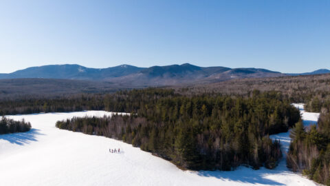
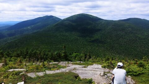
Key existing assets of the High Peaks region of northern Franklin County include world class backcountry woods and waters, and five extensive trail systems providing backcountry access to the recreating public. The backcountry includes a mix of private and public landholdings primarily used for forest production, outdoor recreation, small businesses, and homes for humans and wildlife. Extensive backcountry trail systems have been developed by citizen’s groups with the support of local, state and federal governments to serve hikers, snowmobilers, ATVers, cross-country skiers, paddlers and others. The potential for future development of additional trails systems, such as multi-night backcountry loops within the region, can evolve from the project. A distinctive feature of this accessible backcountry region is its important 70% concentration of Maine’s high peaks above 4000 feet, providing an un-fragmented ecological area with beautiful natural vistas and outstanding recreational challenges, for the enjoyment of residents and visitors alike.
This project proposes to build new connections between four kinds of communities that have a stake in the High Peaks region’s future. Ironically, the high peaks themselves have sometimes served as a natural barrier to making connections within the four communities, so the project proposes connecting communities through backcountry trails in two ways – between different interest communities and within each community. The four kinds of communities are:
- 5 backcountry trails organizations and their local affiliates: the Appalachian Trail (AT), the Maine Snowmobile Interconnected Trail System (ITS), the ATV Maine Trail System (ATV), Maine Huts and Trails (MHT), and the Northern Forest Canoe Trail (NFCT).
- Backcountry private landowners and their organizations:
- The towns within the core High Peaks region: Eustis, Carrabassett Valley, Kingfield, Salem, Strong, Phillips, Avon, Madrid and Rangeley.
- The government agencies with primary resource planning and management responsibilities in the High Peaks region: the Maine Land Use Regulation Commission (LURC), the National Park Service (NPS), the Maine Department of Inland Fisheries and Wildlife (IFW), the Maine Bureau of Public Lands (BPL), and the Maine Forest Service (FS).
The private landowners and the 5 trails organizations are the proposed project’s primary active communities because they own, manage and use the key assets – the backcountry itself, and the trails that provide organized access to it. The members of each of these communities face common concerns and challenges, including concern for financial stability, and the multiple challenges of sustainable land and resource stewardship. In the past, members of these diverse communities have experienced some uneasy relationships, both due to the economic uncertainties facing the region they share and to their diverse cultural outlooks. The project itself will help landowners and trails organizations address these concerns through the many opportunities afforded by participation in the creation of strong connections between the major stakeholders in the High Peaks region. There is an opportunity to preserve and utilize this backcountry through public and private cooperation.
The organized and unorganized towns and 5 government agencies are important participants in the project because they represent all of the other people and groups who have a stake in the successful renewal of the High Peaks region as a key place in Maine’s future outdoor landscape. Basically, the High Peaks region’s role in future Maine will be to help substitute a growing outdoor recreation sector for the declining manufacturing sector, joining revitalized forest products and agricultural sectors to form the natural resource base for future economic stability and growth. Every resident and visitor have a stake in the success of preserving and enhancing the resource base for outdoor recreation developments, always in balance with the continuing needs of sustainable forest products and agricultural enterprises.
Additional key groups and individuals in the region’s outdoor recreation business have a stake in the project’s outcome. The High Peaks region includes two major resorts offering for-profit recreational trail experiences (Sugarloaf and Saddleback ski resorts), plus a number of smaller public and private local trails organizations (e.g. Bigelow, Carrabassett Valley, Saddleback, Rangeley). The four state highways that help define the High Peaks region itself (Routes 4, 16, 27 and 142) include existing and potential future Scenic Roads programs participation. The organized towns located just south of the High Peaks region (Weld, Temple, Avon, Strong, New Vineyard and New Portland) have developed similar backcountry trail assets and can share in the benefits to flow from this project. In fact, the project’s success will influence and support similar efforts throughout Maine’s mountain borderland counties region, the entire four-state Northern Forest region, and, potentially, much of rural America. The future of Maine’s High Peaks region matters to very many people indeed.
In summary, the project has two basic goals – to protect investments in strategic backcountry lands and to enhance recreational access and utilization to that land through further development of world-class trail systems. What will it take to get the project started, and to assure its success?